Login
Register


SAD
Safford Regional/1lt Duane Spalsbury Field Airport
Official FAA Data Effective 2025-11-27 0901Z
Chart Supplement

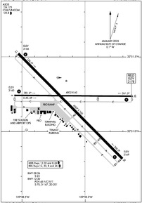
KSAD Airport Diagram
VFR Chart of KSAD
Sectional Charts at SkyVector.com
IFR Chart of KSAD
Enroute Charts at SkyVector.com
Location Information for KSAD
Coordinates: N32°51.20' / W109°38.10'Located 03 miles E of Safford, Arizona on 630 acres of land. View all Airports in Arizona.
Surveyed Elevation is 3178 feet MSL.
Operations Data
|
|
Airport Communications
| ASOS: | 124.175 Tel. 928-235-2373 |
|---|---|
| UNICOM: | 122.800 |
| CTAF: | 122.800 |
| AWOS-3 at CFT (22.3 E): | 119.05 928-687-1116 |
| AWOS-3PT at P33 (38.9 S): | 119.025 520-384-9221 |
| AWOS-3PT at E77 (52.8 W): | 134.125 520-385-4238 |
- APCH/DEP SVC PRVDD BY ALBUQUERQUE ARTCC (ZAB) ON FREQS 134.45/327.15 (SILVER CITY RCAG).
Nearby Navigation Aids
|
| ||||||||||||||||||||||||||||||||||||||||||||||||


Runway 12/30
| Dimensions: | 6007 x 100 feet / 1831 x 30 meters | |
|---|---|---|
| Surface: | Asphalt in Good Condition | |
| Weight Limits: | 45 /F/C/Y/T, S-70, D-147, ST-201 | |
| Edge Lighting: | Medium Intensity | |
| Runway 12 | Runway 30 | |
| Coordinates: | N32°51.52' / W109°38.53' | N32°50.82' / W109°37.70' |
| Elevation: | 3165.6 | 3169.0 |
| Traffic Pattern: | Left | Left |
| Runway Heading: | 135° True | 315° True |
| Markings: | Non-Precision Instrument in good condition. | Non-Precision Instrument in good condition. |
| Glide Slope Indicator | P2L (3.00° Glide Path Angle) | P2L (3.00° Glide Path Angle) |
| REIL: | Yes | Yes |
Runway 08/26
| Dimensions: | 4802 x 60 feet / 1464 x 18 meters | |
|---|---|---|
| Surface: | Asphalt in Good Condition | |
| Weight Limits: | S-23 | |
| Edge Lighting: | Medium Intensity | |
| Runway 08 | Runway 26 | |
| Coordinates: | N32°51.24' / W109°38.56' | N32°51.24' / W109°37.62' |
| Elevation: | 3160.1 | 3178.4 |
| Traffic Pattern: | Left | Left |
| Runway Heading: | 90° True | 270° True |
| Markings: | Basic in good condition. | Basic in good condition. |
| Glide Slope Indicator | P2L (3.00° Glide Path Angle) | P2L (3.00° Glide Path Angle) |
| REIL: | Yes | Yes |
Helipad H1
| Dimensions: | 72 x 72 feet / 22 x 22 meters | |
|---|---|---|
| Surface: | Concrete | |
| Coordinates: | N32°51.01' / W109°38.46' | N0°0.00' / E0°0.00' |
| Elevation: | 3158.0 | |
Services Available
| Fuel: | 100LL (blue), Jet A+ |
|---|---|
| Transient Storage: | Hangars,Tiedowns PPR. |
| Airframe Repair: | MAJOR |
| Engine Repair: | MAJOR |
| Bottled Oxygen: | HIGH/LOW |
| Bulk Oxygen: | HIGH/LOW |
| Other Services: | AIR FREIGHT SERVICES,AIR AMBULANCE SERVICES,AVIONICS,CARGO HANDLING SERVICES,CHARTER SERVICE,PILOT INSTRUCTION,AIRCRAFT RENTAL,ANNUAL SURVEYING |
Ownership Information
| Ownership: | Publicly owned | |
|---|---|---|
| Owner: | CITY OF SAFFORD | |
| 717 MAIN ST | ||
| SAFFORD, AZ 85546 | ||
| 928-432-4000 | ||
| Manager: | CAMERON ATKINS | |
| 4570 E AVIATION WAY | ||
| SAFFORD, AZ 85546-0272 | ||
| 928-432-4235 | EMERG - 435-359-7115. | |
Other Remarks
- MIL ACT INVOF ARPT.
- FOR CD IF UNA TO CTC ON FSS FREQ, CTC ALBUQUERQUE ARTCC AT 505-856-4561.
- LNDG FEE OVR 4000 LB MTOW; MIL/GOV/CHARITY WAIVED OR WITH FUEL PURCHASE.
- ARFF INDEX B.
- 0LL H24 WITH CREDIT CARD.
- ACTVT REIL RWY 08, 12, 26 & 30; PAPI RWY 08, 12, 26, & 30; MIRL RWY 08/26 & RWY 12/30 - CTAF.
Weather Minimums


Instrument Approach Procedure (IAP) Charts


Departure Procedure Obstacles (DPO) Charts

Nearby Airports with Instrument Procedures
| ID | Name | Heading / Distance | ||
|---|---|---|---|---|
 |
KCFT | Greenlee County Airport | 073° | 22.3 |
|
P33 | Cochise County Airport | 199° | 38.7 |
|
P13 | San Carlos Apache Airport | 300° | 60.0 |
|
KDMA | Davis Monthan AFB Airport | 237° | 75.5 |
|
KSVC | Grant County Airport | 099° | 75.9 |
|
KJTC | Springerville Municipal Airport | 011° | 78.1 |
|
KTUS | Tucson International Airport | 236° | 79.6 |
|
KDUG | Bisbee Douglas International Airport | 178° | 82.9 |
|
KFHU | Sierra Vista Municipal-Libby AAF Airport | 205° | 83.9 |
|
KAVQ | Marana Regional Airport | 252° | 84.5 |
|
KSOW | Show Low Regional Airport | 347° | 86.6 |
|
KRYN | Ryan Field Airport | 241° | 89.0 |
Airport Images
 from the northwest")
By: keeganm
 aerial view from the southeast - July 25, 2022")
By: keeganm


