Login
Register


TX42
Fair Weather Field Airport
Official FAA Data Effective 2025-12-25 0901Z
VFR Chart of TX42
Sectional Charts at SkyVector.com
IFR Chart of TX42
Enroute Charts at SkyVector.com
Location Information for TX42
Coordinates: N29°56.19' / W96°2.19'Located 01 miles S of Monaville, Texas. View all Airports in Texas.
Estimated Elevation is 182 feet MSL.
Operations Data
|
|
Airport Communications
| AWOS-3 at TME (10.5 SE): | 119.525 281-574-7296 |
|---|---|
| ATIS at TME (10.7 SE): | 119.525 |
| AWOS-3 at 11R (24.4 NW): | 121.125 979-836-2303 |
Nearby Navigation Aids
|
| ||||||||||||||||||||||||||||||||||||||||||||||||||||||||||||


Runway 13/31
| Dimensions: | 3375 x 30 feet / 1029 x 9 meters | |
|---|---|---|
| Surface: | Asphalt | |
| Runway 13 | Runway 31 | |
| Coordinates: | N29°56.39' / W96°2.42' | N29°55.99' / W96°1.97' |
| Elevation: | 180.0 | 175.0 |
| Declared Distances: | TORA:3375 TODA:3375 ASDA:3375 LDA:3160 | |
| Obstacles: | 28 ft Trees 275 ft from runway | |
Runway 18/36
| Dimensions: | 2400 x 75 feet / 732 x 23 meters | |
|---|---|---|
| Surface: | Turf | |
| Runway 18 | Runway 36 | |
| Traffic Pattern: | Right | |
Runway 09W/27W
| Dimensions: | 2000 x 100 feet / 610 x 30 meters | |
|---|---|---|
| Surface: | Water | |
| Runway 09W | Runway 27W | |
| Coordinates: | N29°55.97' / W96°2.36' | N29°55.99' / W96°1.98' |
| Elevation: | 174.0 | 174.0 |
| Traffic Pattern: | Right | |
| Runway Heading: | 88° True | 268° True |
| Markings: | Buoys | Buoys |
Runway B1
| Dimensions: | 400 x 500 feet / 122 x 152 meters | |
|---|---|---|
| Surface: | Turf | |
Services Available
| Fuel: | 100LL (blue), Automotive Gasoline |
|---|---|
| Transient Storage: | NONE |
| Airframe Repair: | MINOR |
| Engine Repair: | MINOR |
| Bottled Oxygen: | NOT AVAILABLE |
| Bulk Oxygen: | NOT AVAILABLE |
Ownership Information
| Ownership: | Privately Owned | |
|---|---|---|
| Owner: | TX42 HOMEOWNERS ASSOCIATION INC. | |
| 12109 BONANZA PLACE | ||
| BROOKSHIRE, TX 77423 | ||
| 281-702-3331 | ||
| Manager: | LEONARD FIRTH | |
| 12109 BONANZA PLACE | ||
| BROOKSHIRE, TX 77423 | ||
| 281-702-3331 | ||
Other Remarks
- FOR CD CTC HOUSTON ARTCC AT 281-230-5622.
Nearby Airports with Instrument Procedures
| ID | Name | Heading / Distance | ||
|---|---|---|---|---|
 |
KTME | Houston Exec Airport | 137° | 10.7 |
|
KIWS | West Houston Airport | 110° | 20.3 |
|
11R | Brenham Municipal Airport | 314° | 24.4 |
|
KELA | Eagle Lake Airport | 216° | 25.1 |
|
60R | Navasota Municipal Airport | 351° | 26.1 |
|
KDWH | David Wayne Hooks Memorial Airport | 073° | 26.3 |
|
KSGR | Sugar Land Regional Airport | 133° | 27.3 |
|
KIAH | George Bush Intcntl/Houston Airport | 085° | 36.3 |
|
KAXH | Houston/Southwest Airport | 131° | 39.0 |
|
KCXO | Conroe/North Houston Regional Airport | 052° | 40.8 |
|
KARM | Wharton Regional Airport | 188° | 41.3 |
|
KCLL | Easterwood Field Airport | 336° | 42.5 |
Airport Images
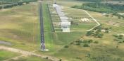
By: pmackey
")
By: jmooney


